MTB Trails
 English
 Italiano
 Deutsch
Trail Description
Partenza da Villa d'Ogna. Vicino all'edificio del comune c'è un pargheggio.
Si sale lungo la strada asfaltata in direzione Nasolino (km 2.3), fino a Valzurio (km 6.3) e si prosegue fino a Spinelli (km 7.7), dove la strada asfaltata lascia il posto ad una sterrata sempre pedalabile anche se con qualche strappo più duro.
La vallata si apre su ampi prati in fondo ai quali si trovano la Baite Mòschel (km 12.2).
Proseguiamo dritti (indicazioni CAI 311 - Baita Bruseda) lungo la sterrata che diventa più ripida e con il fondo più irregolare, con un paio di guadi del torrente Ogna. Attenzione perchè la profondità al centro raggiunge senza problemi la mezza ruota.
Superato il guado su una curva a sinistra (km 13.8) c'è un bivio dove si prende la sterrata di destra; il fondo peggiora e anche se le pendenze non sono del tutto impossibili i sassi di grossa dimensione non consentono di pedalare.
Usciti dal bosco di raggiunge la Baita Pagherola Bassa (km 14.4) e si prosegue sempre sulla sterrata per altri 500m.
Da qui si risale il prato sulla destra (si intravedono i segni lasciati dai mezzi agricoli), si attraversa una fila di alberi e si giuge su un ampio pascolo e lo si attraversa per andare a prendere il sentiero che scende dal Ferrantino (km 15.1) alla destra orografica del sentiero CAI 311. Il sentiero potrebbe non essere visibile nel prato ma è segnato da sassi e paletti.
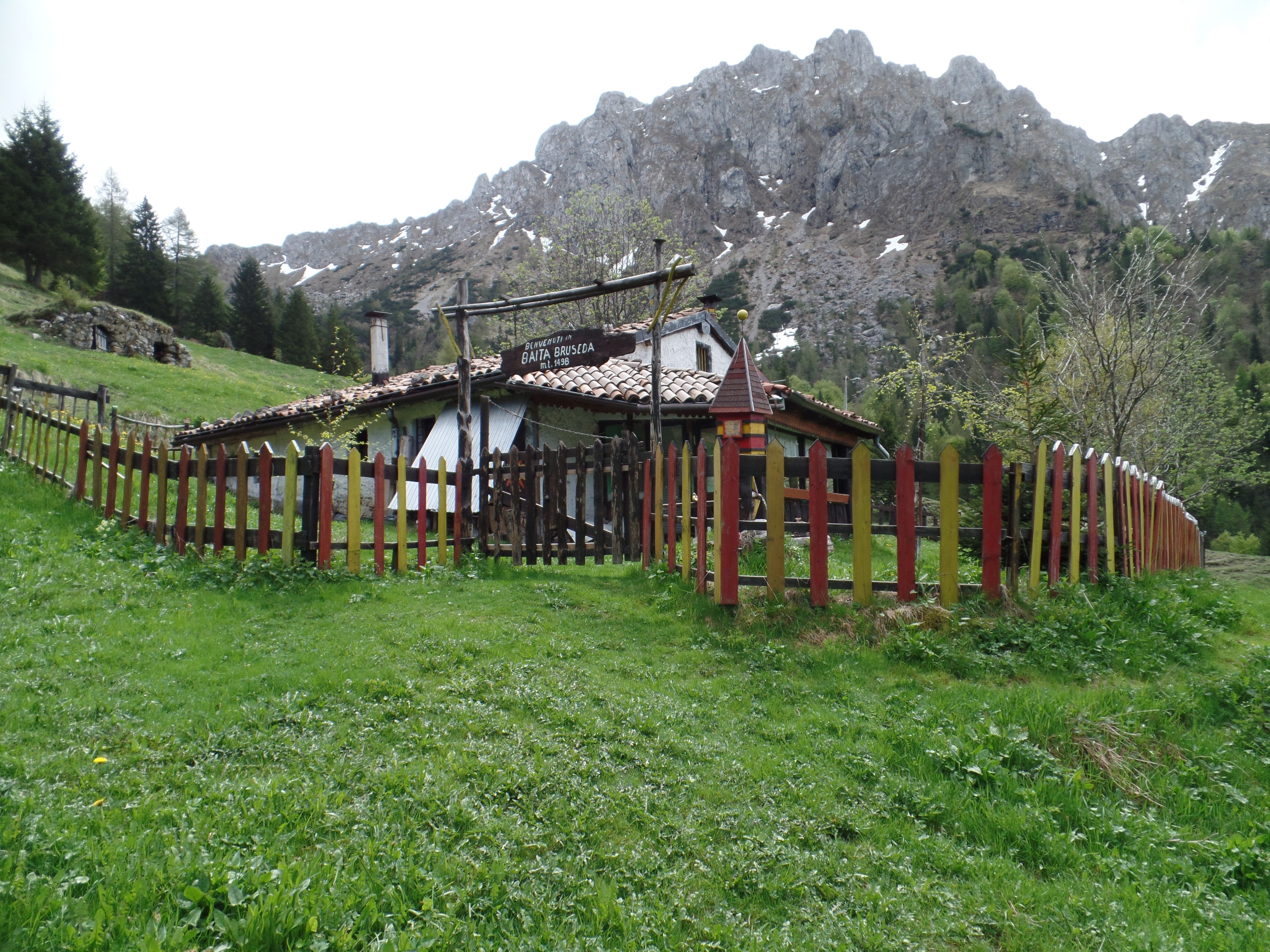
Da qui inizia la prima discesa; si segue il sentiero tenendo la sinistra al bivio (km 15.3) per raggiungere su un sentiero a mezza costa un ulteriore pascolo dove si trova la Baita Brùseda (km 15.5). La discesa prosegue a valle della baita per andare a prendere il sentiero CAI 320, un single track dal fondo compatto senza particolari difficoltà.
In un tornante a destra (km 16.1), si stacca sulla sinistra un sentiero meno visibile che scende su un costone e porta con diversi tornanti non particolarmente tecnici nuovamente alle Baite Mòschel (km 17.2) dopo l'ennesimo guado del torrente Ogna.
Raggiungeremo il percorso di salita incrociandolo e proseguando oltre (indicazioni CAI 311 - Colle Palazzo).
Si segue la sterrata che inizia a salire con pendenze non sempre pedalabili fin a quando in un tratto rettilineo si trova un cartello che sulla sinistra indica il Colle Palazzo (km 18.6). Il sentiero nella sua parte iniziale non è molto visibile visto che parte in mezzo agli alberi ed anche proseguendo sale nel bosco senza che in alcuni punti non sia del tutto facile da individuare. Non dovrebbe comunque esserci rischio di perdersi.
Si incontrano alcune radure con qualche baita fino a quando non si raggiunge la sterrata che sale da Oltressanda Alta (km 21.7).
Si sengue per poco la sterrata e dove questa inizia a scendere sul fianco della montagna si attraversa un prato (km 22.1) e si prende la sterrata che sale nel bosco (km 22.3).
Qui dopo un tratto iniziale sterrato inizia un sentiero nel bosco che continua a salire, non sempre pedalabile, passando sotto la vetta di Cima Ba.
Si ridiscende lungo il sentiero fino ad un alpeggio con alcune malghe dove il sentiero diventa nuovamente sterrata. Dove questa inizia decisa a scendere (km 24.2) si passa a fianco dell'ultima malgae si entra nel bosco. Inizialmente il sentiero non si vede, ma dopo una brevissima risalita lo si individua senza alcuna difficoltà.
Inizia qui l'ultima discesa, tutta su single track; nella prima parte la presenza di numerose radici potrebbe mettere in difficoltà in caso di fondo umido, ma poi via via le radici diminuiscono lasciando il posto ad un bellissimo sentiero, con pochi passaggi tecnici, qualche tratto abbastanza ripido, qualche tratto molto filante e diversi tornanti.
A fondo sentiero si arriva ad Ardesio (km 27.7) da dove si rientra verso il punto di partenza; conveine restare sulla strada più alta (via Cunella) rispetto alla SP 49 per evitare lo strappetto finale per risalire al parcheggio del comune.
La traccia è stata ripulita dalle soste.
Departure from Villa d'ogna. Near the building of the town there is a parking.
Climb along the paved road in the direction of Nasolino (km 2.3), up to Valzurio (6.3 km) and continues up to Spinelli (km 7.7), where the paved road gives way to a dirt track, always manageable though with some tear harder.
The valley opens up on the meadows at the bottom of which are the Huts Mòschel (12.2 km).
Continue straight ahead (sign for CAI 311 - Hut Bruseda) along the dirt track that becomes steeper and the bottom more uneven, with a couple of fords of the river Every. But be careful, because the depth at the centre reaches without problems the half wheel.
Passed the ford on a curve to the left (km 13.8) there is a junction where you take the dirt road to the right; the bottom gets worse and even if the slopes are not impossible as the stones of large size do not allow to ride a bike.
Out of the wood, reaches the Hut Pagherola Low (km 14.4) and you continue on the dirt road for another 500m.
From here go up the meadow on the right (you can see the marks left by agricultural vehicles), you go through a row of trees and giuge on a large pasture and cross it to go to take the path that descends from the Ferrantino (km 15.1) to the right bank of the CAI 311. The trail may not be visible in the lawn but is marked by stones and stakes.
From here begins the first drop-down; follow the path keeping to the left at the fork (km 15.3) to reach on a trail half way up the coast a further pasture where you will find the Hut Brùseda (km 15.5). The descent continues to the valley of the hut to go get the CAI 320, a single track from the bottom of the compact without any special difficulty.
In a right-hand bend (km 16.1), it is detached on the left, a path less visible that descends on a ridge and port with several hairpin bends that are not particularly technical back to the Huts Mòschel (km 17.2) after yet another ford of the stream Every.
We will reach the path of ascent incrociandolo and proseguando beyond (directions CAI 311 - the Hill Palace).
You follow the dirt track which begins to climb with slopes not always pedaled since when a straight stretch is a sign on the left indicates the Colle Palazzo (km 18.6). The trail in its initial part is not very visible since the part in the middle of the trees and continuing up through the woods, without which in some points is not completely easy to locate. There should be no risk of getting lost.
You will encounter some clearings with some hut until you reach the dirt road that climbs up from Oltressanda High (km 21.7).
You sengue for a little while, the dirt, and where this begins to fall on the side of the mountain, and crosses a meadow (km 22.1) and take the dirt road that climbs into the forest (km 22.3).
Here, after an initial dirt road begins a trail in the woods that continues to rise, not always road, passing under the summit of the Top Ba.
You descend along the trail up to a mountain pasture with a few huts where the trail becomes a dirt road. Where this begins is determined to get off (km 24.2), we go to the last malgae enter the forest. Initially the path is not seen, but after a short ascent you locate it without any difficulty.
Here begins the last downhill, all single track; in the first part the presence of many roots could put in difficulties in the event of a damp bottom, but then via the roots decrease, leaving the place to a beautiful trail, with a few technical steps, some stretches quite steep, some stretches are very narrow and several bends.
At the bottom of the trail you will come to Ardesio (km 27.7) from where you return to the starting point; conveine stay on the road most high (via Cunella) compared to the SP 49, in order to avoid the spurt of the final climb to the parking lot of the town.
The track has been cleaned up from the stops.
Map/Elevation
Pictures